ADVERTS
Os Climas do Brasil: Um Panorama Completo das Características Climáticas por Região
O Brasil, devido à sua extensão territorial e diversos fatores geográficos, apresenta uma notável diversidade climática. Esta riqueza de variações climáticas tem profundo impacto na biodiversidade, agricultura e desenvolvimento socioeconômico das diferentes regiões do país. Para compreender melhor esta complexidade, é fundamental analisar as diferentes classificações climáticas e suas características específicas.
Sistemas de Classificação Climática
Os estudiosos desenvolveram diferentes métodos para classificar os climas brasileiros, sendo os mais relevantes os sistemas de Strahler e Köppen. A classificação de Strahler, pertencente à escola de climatologia Dinâmica, fundamenta-se no estudo do movimento das massas de ar e sua influência sobre as regiões. Por outro lado, o sistema Köppen analisa elementos específicos como temperatura e precipitação, considerando sua distribuição ao longo das estações do ano.
ADVERTS
Características Gerais do Clima Brasileiro
A posição geográfica do Brasil, com a maior parte de seu território localizada na zona intertropical e apresentando predominância de baixas altitudes, resulta em climas predominantemente quentes, com temperaturas médias superiores a 20°C. Esta configuração permite a atuação de diferentes massas de ar e sistemas frontais, que moldam as características climáticas específicas de cada região.
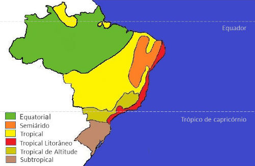
Clima Equatorial
O clima equatorial domina aproximadamente 5 milhões de quilômetros quadrados da Amazônia Legal, abrangendo os estados do Acre, Amazonas, Amapá, Rondônia, grande parte do Pará (exceto sua porção sudeste), noroeste do Maranhão e do Mato Grosso, além de parte de Roraima. Este clima caracteriza-se por:
- Temperaturas médias entre 24°C e 26°C
- Temperatura do mês mais frio sempre superior a 18°C
- Baixa amplitude térmica anual (até 3°C)
- Precipitação abundante (superior a 2.500 mm/ano)
- Umidade atmosférica elevada (geralmente acima de 80%)
A massa equatorial continental (mEc) é responsável pelas chuvas de convecção, enquanto no inverno, a região ocasionalmente recebe influência de frentes frias da massa polar atlântica (mPa), causando o fenômeno conhecido como “friagem”.
Clima Tropical
O clima tropical predomina no Planalto Brasileiro, estendendo-se por grandes áreas do Planalto Central e das regiões Nordeste e Sudeste. Suas principais características incluem:
- Temperaturas médias superiores a 20°C
- Amplitude térmica anual de até 7°C
- Precipitação entre 1.000 e 1.500 mm/ano
- Duas estações bem definidas: inverno seco e verão chuvoso
No Nordeste, observa-se uma transição gradual para o clima semiárido, com estação seca mais prolongada. O litoral oriental nordestino, do Rio Grande do Norte até a Bahia, apresenta chuvas abundantes, concentradas no outono e inverno.
Clima Tropical de Altitude
Este clima ocorre nas áreas mais elevadas do território brasileiro, principalmente nas Serras do Mar e da Mantiqueira, além do planalto que se estende ao norte de São Paulo, sul de Minas Gerais e Mato Grosso do Sul. Características principais:
- Temperaturas médias mensais entre 18°C e 22°C
- Amplitude térmica anual de 7 a 9°C
- Precipitação entre 1.000 e 1.500 mm/ano
- Período chuvoso: setembro a março
- Período de estiagem: abril a setembro
As chuvas de verão são intensificadas pela ação da massa tropical atlântica (mTa), enquanto no inverno, a influência da massa polar atlântica (mPa) pode ocasionar geadas com temperaturas negativas.
Clima Tropical Atlântico
Este clima atua na faixa litorânea desde o sul do Rio Grande do Norte até o Rio Grande do Sul, apresentando:
- Temperaturas médias entre 18°C e 26°C
- Amplitude térmica crescente com o aumento da latitude
- Precipitação superior a 1.200 mm/ano
- Distribuição desigual das chuvas ao longo da costa
Clima Semiárido
Característico do sertão nordestino, o clima semiárido apresenta:
- Temperaturas médias elevadas (cerca de 27°C)
- Amplitude térmica anual de aproximadamente 5°C
- Precipitação inferior a 800 mm/ano
- Alta irregularidade na distribuição das chuvas
Em anos com distribuição normal de chuvas, as necessidades básicas da população são atendidas. No entanto, períodos prolongados de seca podem causar situações críticas para a região.
Clima Subtropical
Predominante na região Sul do Brasil, especialmente no Planalto Meridional, o clima subtropical caracteriza-se por:
- Temperaturas médias inferiores a 18°C
- Amplitude térmica anual entre 9°C e 13°C
- Precipitação abundante (1.500 a 2.000 mm/ano)
- Boa distribuição das chuvas ao longo do ano
- Verões amenos e invernos rigorosos nas áreas mais elevadas
- Ocorrência frequente de geadas e ocasional de neve
Esta diversidade climática do Brasil não apenas influencia a formação das paisagens naturais, mas também determina os ciclos agrícolas, as atividades econômicas e os modos de vida das populações em cada região do país.