ADVERTS
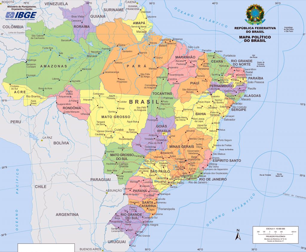
Map of Brazil, everything about the Map of Brazil and the Image of the Map of Brazil
The map of Brazil is a visual representation of a certain region and allows you to position yourself and even measure distances using the scale contained on the map itself. Brazil, for example, has 8,514,876.599 km² of area, thus the 5th largest country in the world, second only to the United States, China, Canada and Russia, which is the largest country in the world.
Our country is the largest in South America, and ranks fifth among the largest countries in the world. It is still the third largest in the Americas, and Brazil's special feature is that it borders almost all countries in South America, Paraguay, Argentina, Uruguay, Colombia, Peru, Bolivia, Suriname, Venezuela, Guyana and French Guiana. The exceptions are Ecuador and Chile. Brazil still has the largest forest in the world and one of the largest territories of forest areas on the planet.
ADVERTS
Image of the Map of Brazil (click to enlarge)

How many states does Brazil have?
Brazil is made up of 26 states plus the federal district.
States in the northern region of Brazil
Amazonas, Roraima, Amapá, Pará, Acre, Rondônia and Tocantins
States in the northeast region of Brazil
Maranhão, Piauí, Ceará, Bahia, Rio Grande do Norte, Paraíba, Pernambuco, Alagoas and Sergipe.
States in the central-western region of Brazil
ADVERTS
Mato Grosso, Mato Grosso do Sul, Goiás and the federal district Brasília
States in the southeast region of Brazil
Espirito Santo, Minas Gerais, São Paulo and Rio de Janeiro.
States in the southern region of Brazil
Paraná, Santa Catarina and Rio Grande do Sul.
What are the biggest states in Brazil?
1st Amazon – Amazonas is the largest state in Brazil and has approximately 1,570,745m²
2nd Para – In second place in terms of dimensions comes Pará, with around 1,247,689m²
3rd Mato Grosso – The state of Mato Grosso takes third place and all this due to its size of 903,357m²
4th Minas Gerais – In fourth place is Minas Gerais land with 588,528m²
5th Bahia – In fifth place comes the state of Bahia with around 564,692m²
Coast of Brazil
Brazil has around 7,491 kilometers of coastline, making Brazil the 16th country with the longest coastline in the world. There are 17 Brazilian states that make up this entire stretch of coastline.
Which states in Brazil are bathed by the ocean
There are 17 states bathed by the ocean in Brazil, are they:
- Rio de Janeiro
- São Paulo
- Holy Spirit
- Paraná
- Santa Catarina
- Rio Grande do Sul
- Bahia
- Sergipe
- Alagoas
- Pernambuco
- Paraíba
- large northern river
- Ceará
- Piauí
- Maranhão
- For
- Amapá
Maps then and now
Get to know how Maps were made in the past and now and the evolution of Maps, also watch a documentary that tells the story of Maps.
